GIS Program
The PWSSP has implemented a GIS program and
encourages all Navajo Nation community
planners to become involve in environmental
planning in their community development
initiatives. Protection of the community's drinking
water source(s) is very important as it will have
serious impact on the community. Planning
support systems can measure and compare
performances of different planning scenarios
according to planner- or citizen-defined indicators
for land use, transportation, natural resources,
and employment, to name a few. As communities
grow, concerns over the placement of gas
stations, sewer lagoons as opposed to septic
tanks, hospitals, mortuaries, industrial buildings
all need to be considered.
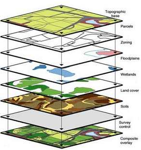
GIS's mission is to establish a positive working
relationship to provide computer generated map of
various layers, boundaries and community
watering point information on the Navajo Nation.
PWSSP will continue to collect spatial data for
access and distribution of non-sensitive data to
requesting parties.
GIS program is preparing to implement a map
module and make it available for chapter planners
using Internet Mapping capabilities.
GIS Datasets
GIS program will continue to collect and use
geographic datasets for access and distribution of
non-sensitive data to requesting parties. Currently,
general Navajo Tribal Utility Authority (NTUA)
dataset are secured by approval of NTUA for the
use of GIS dataset license. Navajo EPA-PWSSP
will not display their data outside the office without
a written consent of NTUA. However, other GIS
dataset have come from Navajo Land Department and is available for the general public.
Maps:
All maps can be made to your desired specifications
from an 8.5"X11" sheet to a 42"X63" Land Map.
Most maps can be produced for you in a timely
manner, depending on the information needed on the
requested map.
Listed Above are some Maps that are commonly
requested. They are in an 8.5" X 11" format but can be
ordered through the Navajo PWSSP GIS Program.
CLICK HERE to view pricing for maps.
To place an order:
CLICK HERE to fill out the Map Request Form which
is in PDF format and/or print form and fax to (928)
871-7818 to the PWSSP GIS Program.
Disclaimer
All map information provided is still under development but is made available to the requesting party for the
purpose of identifying, displaying general information on land. No warranty, expressed or implied, is made
by the Navajo Nation EPA-PWSSP as to the accuracy of this data, nor shall the fact of distribution constitute
any such warranty, and no such responsibility is assumed by the Navajo Nation EPA-PWSSP in connection
therewith.